
PT Chandra Asri Pacific Tbk Reality Capture project for all CAP owned Petrochemical plants in West Java


Project Synopsis
Utilizing latest 3D laser scanning technology from Leica Geosystems – RTC 360 laser scanners
7 nos large scale industrial plant laser scanned in 1 year period
Approximately 50,000 scan locations; approximately 65 TB color point cloud data
Met stringent Client QA/QC requirements for completeness & accuracy of 3D point cloud.
Challenges faced during implementation; the weather and a major plant turnaround mid project implementation.
PT Meindo Elang Indah is one of the leading EPCI contractors in Indonesia, providing fully integrated solutions in Engineering, Procurement, Construction, & Installation services for the Petrochemical, Energy, & upstream Oil & Gas Industry supported by FSD SKIES Digital


OFFSHORE EPCI
Engineering, Procurement, Construction and Installation of Offshore Platforms, Modules and Pipelines

ONSHORE EPC
Engineering, Procurement, Construction and Installation of Offshore Oil & Gas, Energy and Petrochemical Facilities

BROWNFIELD SERVICES
Brownfield Modifications and Maintenance for Onshore & Offshore Facilities

Yard Fabrication
Fabrication of Steel Structures, Piping Spools and Manifolds, Onshore & Offshore Modules

Project Synopsis
FSD SKIES Digital business unit under PT FSD Indonesia was appointed by AVEVA Specialist Solution Provider (SSP) for Indonesia.
This shows the trust by AVEVA, the leading engineering, operations, & performance optimization solution provider across various industries in the capabilities of FSD SKIES Digital to re-sell, support & implement its solution.
PT Meindo Helang Indah became our first customer in purchasing AVEVA’s Integrated Engineering solution consisting of AVEVA E3D, AVEVA Engineering & AVEVA P&ID


Project Synopsis
FSD SKIES Digital secures PT a Api (PERSERO) jointly with PT ODP Indonesia
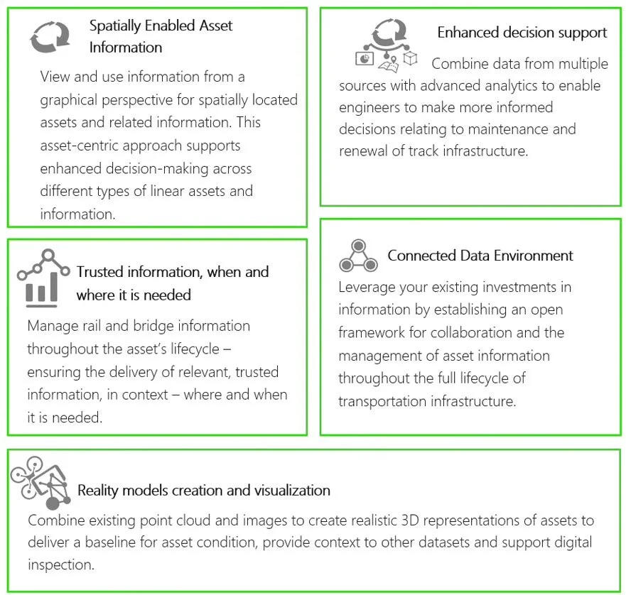
The project entails the supply, implementation & consultancy services of Bentley Systems Asset Wise Linear Analytics solution, the transportation industry’s leading decision support system that enables proactive management and decision support for linear assets

Qatar Energy Reality Capture (3D Laser Scan & 3D Modeling) project
for all onshore facilities in Dukhan Production Field


Project Synopsis
Utilizing latest 3D laser scanning technology from Leica Geosystems – RTC 360 laser scanners
Over 150 plus sites in the Qatari desert to be laser scanned and 3D modeled
Challenges faced on on-going implementation; the weather, large number of locations to be completed in a short schedule before the summer months.
Key success factors; experienced team capable of conducting site work and finalizing data whilst in Qatar. These ensures that all data sent back to home office for 3D modeling has been QA/QC-ed and approved by Client